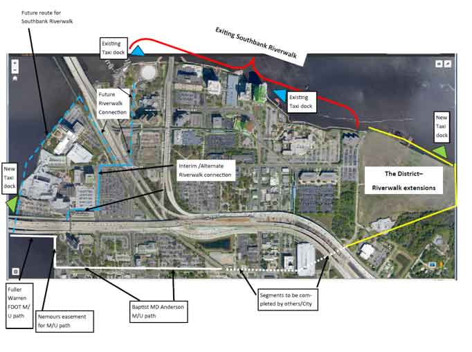
Reprinted below is a working graphic Lori Boyer created to assist in discussion of existing and future Southbank Riverwalk improvements, water taxi docks, and the multi-use path that will connect the loops. The ultimate goal is a complete loop for walkers and runners and publicly available river crossings for those individuals both along bridges and by water taxi. This is a working concept that she personally uses in reviewing plans for both public and private improvements.

From Loriboyer.org: Let’s start with the Riverwalk and multi-use path. As shown in red, the Riverwalk currently extends from Friendship Park to the far end of the School Board site. To the west and south there are a number of obstacles to extension of the Riverwalk from Friendship Park. First, we encounter the St Johns Marina and boat ramp which is immediately adjacent to the Acosta Bridge followed immediately by the railroad bridge (if you were to build the Riverwalk over the water, and go up in height to allow boat access to the ramp under the walkway, you have to get back down to get under the Acosta bridge and up again over the railroad bridge. The geometry is impossible unless you go far out into the water where currents and navigation create other issues.
Based on those challenges, I think the most workable and cost-effective solution is to delineate a path that follows San Marco Boulevard from Friendship Park to Prudential, crosses the railroad tracks at Prudential, and then returns to the waterfront. That is shown in a blue dashed line. The walk along San Marco/Prudential/and back to the water could be signed, landscaped and enhanced with pavers or other materials to identify that it is a continuation of the Riverwalk.
There is a development proposal for a multi-story apartment project that is currently in the review stages for the parcel immediately adjacent to the railroad tracks. As part of the design review process, the developer has agreed to include a 12 foot wide walkway with four feet of landscape on either side along the railroad frontage of the parcel. Along the riverfront, there is an existing 8 foot walkway adjacent to the bulkhead and the plans contemplate that the developer will provide a contiguous 12 foot walkway on its site in addition to landscape and lighting. This would essentially extend the Riverwalk to the Aetna parcel. At this point we would temporarily reach a dead-end so I envision an alternate temporary overland connection that would get users from Prudential to the Fuller Warren Bridge.
The solid blue line represents a temporary linkage along Prudential and Palm and through the corner of the Baptist parcel to connect to Fuller Warren. As Baptist implements plans for redevelopment of its parking garage and entrance, and explores potential upgrades to this section of Palm Avenue, we want to keep the opportunity open for this temporary connection until such time as funding is available to complete the actual Riverwalk connection. Please refer to the solid blue line.
Ultimately, the Riverwalk would connect from the multi-family parcel discussed above, in front of the Aetna building and the Wolfson and Baptist sites back to the Fuller Warren. We will of course need easements from the upland owners in order to obtain the submerged land leases necessary to construct the Riverwalk in the water- even if there is no direct access to their parcel. We have begun those conversations.
Why Fuller Warren as an essential connection point? FDOT is committed to construct a separated multi-use path adjacent to the southbound lanes of the bridge as part of its new Fuller Warren project. That project is slated for 2019 and when complete would connect Riverside to the Southbank for pedestrians and bicycles. That is shown in solid white along the bridge. We have been in discussion with FDOT for a number of years regarding an under-bridge park (think RAM) and once construction is complete on the bridge and the area is no longer required for staging, we hope that park/plaza would be an anchor for the MU path on the Southbank.
Gary Street at Palm Avenue is a dangerous and difficult intersection for pedestrians and cyclists. That led us to look for an overland loop connection that avoided Gary Street along the bridge overpass. Nemours generously agreed to allow the path to be extended along their riverfront to get users to the less congested Children’s Way/Nira linkage. During the approval of the re-zoning for Baptist/MD Anderson, the MU path was included along the north side of Nira as part of the site design. Construction of that segment will be completed by the owner along with construction of the new cancer center and parking garage. These sections are depicted by the solid white line.
A short white dotted segment remains to connect the loop to the Kings Avenue garage. As future development occurs along the route, we will look to incorporate the path in those plans as well as any City plans for improvements within the right of way.
That brings us to Kings Avenue garage- a public parking and transit location that would serve users of the path as well. From the garage, there is access under the Overland Bridge to The District which has committed to connect the over land and waterfront segments of the loop as part of their development plans.
If you are still reading- a quick note on across river access for pedestrians. Of course Acosta and Main Street bridges currently have walkways- albeit minimal ones. The new Fuller Warren path will provide a third, and enhanced, pedestrian bridge crossing. From a water standpoint, my goal is to provide docking opportunities for public water taxi service at reasonable intervals that connect to upland activity centers along the Southbank and Northbank waterfront. On the map, the blue triangles represent existing taxi docks and the green triangles represent future locations that would fill-out the network.
Of course this won’t happen overnight. But, it won’t happen at all if we don’t have a vision that we are implementing step by step. There are other significant elements not shown- the graphic would be too busy- but new Southbank public parking facilities, the AIA vision for feature nodes, plans for future expansion of MOSH , Riverplace Boulevard reconstruction, docking for recreational boats, etc. are all additional layers in the works. It is an exciting time on the Southbank driven by private investment and new development activity- but with a vision for public access and amenities shaping the background.